
Background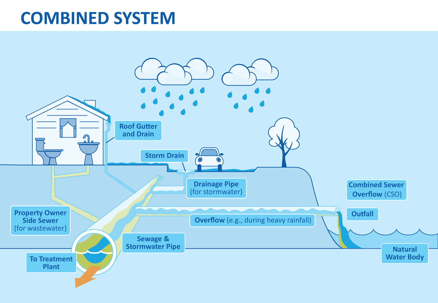
A portion of the City's sewer system runs through Mill Creek Park and is a Combined Sewer - meaning it collects both wasteland from our homes and buildings and rainwater from our land. When it rains a lot, this mix of water can overflow into Mill Creek and its smaller streams, Calvary Run and Bears Den Run.
Right now, there are 18 places where these overflows can happen. Most of them (15) go directly into Mill Creek, while two flow into Calvary Run and one into Bears Den Run.
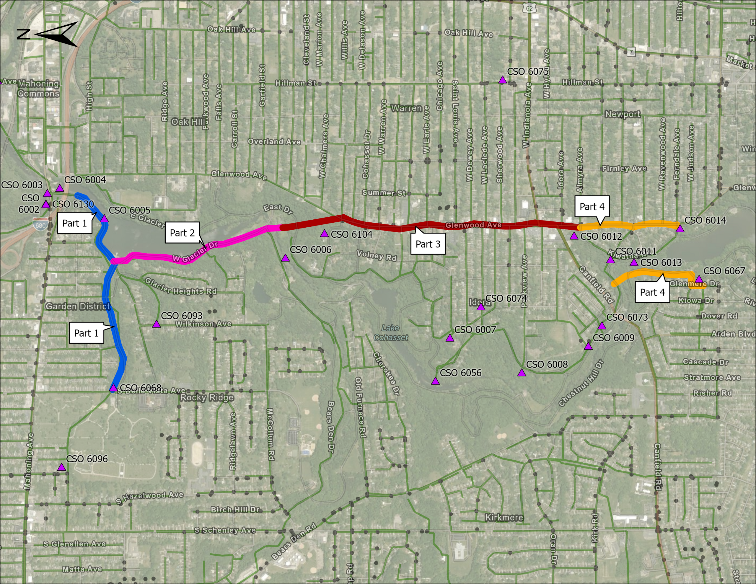
The City's Mill Creek Interceptor Sewer Project lays out a four-part plan to reduce the amount of combined sewer overflow entering our waterways by installing larger diameter pipe and culvert. The four parts are based on location and connections to the existing system and will be implemented at different times.
They are:
Part 1: Build a new pipe along Calvary Run Dr and Price Rd from Weaver Rd to S Belle Vista Ave (blue).
Part 2: Continue building the new pipe along West Glacier Drive to Memorial Hill Drive near Slippery Rock Pavilion (pink).
Part 3: Continue the pipe to the intersection of Glenwood and Almyra Avenues (red).
Part 4: Extend the pipe along Glenwood Ave to a point just west of the intersection of Glenwood and Midlothian Avenues (orange).
These new pipes will help carry more water during heavy rains, reducing overflows into the creek and its streams. This plan aims to improve water quality in Mill Creek Park and protect the environment.
Currently the City is working on the design of Parts 1 and 2 of this project.
Mill Creek Sewer Improvement Project: Parts 1 & 2 Progress
-
Timeline item 1 - complete
Preliminary Design
Preliminary design for the Mill Creek Interceptor Sewer Project develops initial concepts and evaluates feasibility. During this phase, engineers study the area's geography, population, and water use patterns. They create rough sketches of where pipes might go and how big they need to be. Preliminary design also involves estimating costs and figuring out how long construction might take. Engineers consider environmental impacts too, like how to protect nearby streams. This early planning helps catch potential problems before they become expensive mistakes. It also gives town leaders and residents a chance to share their thoughts on the project. By taking the time to do a good preliminary design, we can make sure the final sewer system will serve the community well for many years to come.
The preliminary design phase includes lots of data collection prior to moving to final design.
Data Collection for this phase included:
- Field Investigations
- Stream and Wetlands Assessments
- Topographic Survey
- Soil Studies and Geotechnical Investigations
- Sewer Inspections
- Wildlife Studies
- Cultural Resources Survey
Learn more about each data collection effort below.
-
Timeline item 2 - active
Final Design
After preliminary design, the next step is final design. During this phase, engineers use the information gathered and decisions made in preliminary design to create detailed plans that show exactly how the sewer will be built. Some elements of final design include:
- Sizing the sewers based on model results and calculations from preliminary design
- Finalizing the location and elevation of the sewers based on soil characteristics, land use, topography, and nearby utilities
- Identifying and addressing constraints such as private property and environmental preservation areas
- Choosing the right materials for construction and installation based on cost and site-specific needs
- Developing detailed cost estimates and construction schedules
- Making sure the sewer system will last a long time
A well-designed sewer system, from start to finish, makes life better for all the people who live in the area.
-
Timeline item 3 - incomplete
Construction
During construction, the Contractor builds the project based on the plans developed during the final design.
Learn more about the current and past phases of this project.
Data Collection: Why It Matters
When engineers start planning a big project, they need to visit the place where they'll build. This is called data collection or a field investigation. It's like being a detective for the project! Here's why it's important:
- See it for real: Engineers get to look at the area with their own eyes, not just from maps.
- Find problems early: They can spot things that might cause trouble later.
- Make better plans: Knowing what the place is really like helps them make smarter choices.
- Know the true cost: They can guess how much money the project will need more accurately.
- Follow the rules: They make sure the project follows all the local, state and federal laws.
- Check if it works: They figure out if their idea can actually be built there.
- Learn about special problems: They might find out they need special tools or experts.
- Plan what they need: They can list all the things and people they'll need for the job.
- Remember how it was: They can take notes about how the place looks before they start, so they can compare later.
Field investigations help engineers make sure their project will work well and not have big surprises later!
Field Investigations for this project include:
- Stream and Wetlands Assessments: Assessments play provide valuable insights into the health and functionality of our streams and wetlands. These studies inform land-use decisions, ensuring that development projects consider their impact on these sensitive areas. For this project, these assessments will let the project team know areas that sewers cannot go due to regulations that protect streams and wetlands.
- Surveys: Before any major construction begins, surveys are essential to ensure proper design and planning. Topographic surveys map out the land's contours, elevation changes, and existing features so designers know where infrastructure can go, and where it can't go.
- Geotechnical Investigations: These investigations involve a series of tests and analyses to understand the soil and rock properties beneath the surface. Engineers drill boreholes, extract soil samples, and conduct various field and laboratory tests to determine how strong the ground is, what the soil is made of, and if too much water will impact the soil's stability. Geotechnical investigations help identify potential challenges early in the design process, allowing for more accurate cost estimates and safer, more efficient construction plans. By doing these investigations, engineers can design structures that are not only stable and durable but also just right for the specific ground they're on. This helps prevent problems later and makes sure our buildings and bridges stay strong for a long time, no matter what kind of ground they're built on.
- Sewer Inspections: Sewer inspections help us understand what's going on underground with our pipes. Experts use special cameras on long cables to look inside the sewer pipes and find problems like cracks, blockages, or places where tree roots have grown into the pipes. This inspection tells us the current sewer condition and helps us decide if/where it needs repaired or replaced. It's like making sure a cup isn't cracked before pouring in more water.
Knowing about sewer problems early helps engineers make better decisions. They can figure out if they need to change their designs to work with what's already there. This prevents messy and expensive surprises later when construction starts. - Wildlife Studies: These studies help us understand how our construction plans might affect the animals and plants living in the area. Experts observe local animals and plants, looking for rare or protected species and signs of wildlife activity. By doing wildlife studies early, we can build what we need while minimizing harm to local ecosystems. It's about creating a balance where both humans and animals can thrive. These studies are a key step in responsible development, ensuring our projects consider the needs of wildlife alongside human goals.
- Cultural Resources Survey: A cultural resources survey is an important part of planning a sewer project. It helps us find and protect old things that are special to our community, like Native American artifacts or historic buildings. By doing this survey early, we can make sure our sewer project doesn't damage these important pieces of our history.
In preliminary design, the team gathered information, identified potential challenges, and developed a high-level project plan. In final design, the team builds on this plan, adding and iterating on details until the plans are ready to be constructed.
Some changes that can be made during final design include:
- Identifying specific locations and a project plan for demolition work, where old sewers will be removed
- Developing specific elevations and sizes for the new manholes, junction chambers, and regulation chambers that will be built
- Adjusting sewer sizes to meet design requirements
- Finalizing how the new sewers will be connected to existing sewers, and how existing sewers will be modified to accommodate the new project
- Choosing whether to install a single sewer or two smaller parallel sewers in specific portions of the project
- Adjusting the angles at which sewers connect to each other to change how quickly water flows through the sewers
- Updating cost estimates to reflect the additional information about what materials are needed and the extent of demolition and construction work
- Creating a construction schedule and other reports and information that contractors need to build the project
Once the design has been finalized, the next step is constructing the first phases of the project!


